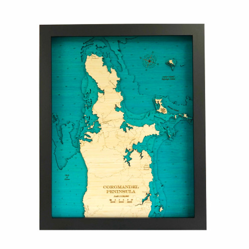


A layered bamboo art map of the Coromandel Peninsula, celebrating the harbour, coastline and townships of this much-loved coastal region.
This Matai Gallery large long art map captures the Coromandel Peninsula from Manaia in the south to Colville Bay in the north, centred on Coromandel Harbour. Full detailed street maps are included, allowing familiar roads, coastal places and personal connections to be recognised within the artwork.
Known for its beaches, harbour views, coastal roads, holiday memories and strong connection to the sea, the Coromandel is a place that holds meaning for locals, bach owners, travellers and those who return to the peninsula year after year.
The long format gives this piece beautiful presence, allowing the shape of the peninsula, harbour and surrounding coastline to be appreciated as a statement artwork.
Carefully constructed by hand, layer by layer, in our Wairarapa workshop, this seven-layer bamboo art map brings depth, texture and warmth to a landscape shaped by harbour, coast, roads and memory.
Choose from a black or white frame to suit your space. Made from layered bamboo ply and framed in FSC pine, each map is carefully finished by hand. Due to the handmade construction and natural materials used, each piece may vary slightly from the image shown, making every map unique.
Details:
- Location: Coromandel Peninsula
- Features: Manaia, Coromandel Harbour, Colville Bay and full detailed street maps
- Size: Large long
- Layers: 7
- Frame dimensions: 40cm wide x 100cm high x 4cm deep [confirm orientation]
- Weight: approx. 10kg / 10,000g
- Frame options: Black or white
- Full street detail included
- Carefully constructed by hand in our Wairarapa workshop