
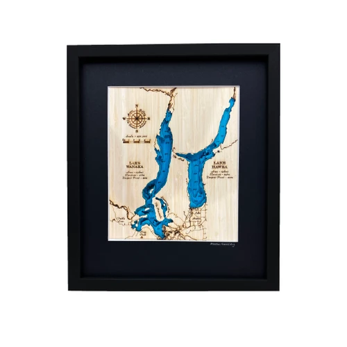
A layered bamboo art map of Lake Wānaka and Lake Hāwea, celebrating two of Central Otago’s most beautiful alpine lakes.
This Matai Gallery small art map features the bathymetry of Lake Wānaka and Lake Hāwea, showing the depth and shape of these striking twin lakes. While Lake Wānaka is one of New Zealand’s largest lakes, nearby Lake Hāwea has its own remarkable depth and character, making this piece a fascinating celebration of the landscape below the surface.
The map includes Wānaka town, Lake Hāwea, The Neck, Stevenson’s Arm, The Peninsula, Treble Cone and Roys Peak - places closely connected to lake days, mountain views, holidays, walking tracks and memories of Central Otago.
Carefully constructed by hand, layer by layer, in our Wairarapa workshop, this four-layer bamboo art map brings depth, texture and warmth to a landscape shaped by water, mountains and personal connection.
Choose from a black or natural frame to suit your space. Made from layered bamboo ply and framed in FSC pine, each map is carefully finished by hand. Due to the handmade construction and natural materials used, each piece may vary slightly from the image shown, making every map unique.
Details:
- Location: Lake Wānaka and Lake Hāwea
- Features: Wānaka town, Lake Hāwea, The Neck, Stevenson’s Arm, The Peninsula, Treble Cone and Roys Peak
- Size: Small
- Layers: 4
- Frame dimensions: 300mm wide x 380mm high x 28mm deep
- Weight: approx. 1kg
- Frame options: Black or natural
- Carefully constructed by hand in our Wairarapa workshop